Summary
![<em>Graphical abstract of the team Geological Systems highlighting (i) its structure in three distinct but highly complementary working groups, (ii) our various scientific expertise, methods and research areas, (iii) our emblematic research topics, (iv) as well as the main transverse research themes within the team itself and beyond its own frontiers at local, national, European and international levels.</em>](/websites/_processed_/c/c/csm_geosys_figure_e53fbbb69b.png)
Presentation
The research activity of our team focuses on the study of the Earth’s structure and the processes acting on its evolution over geological times. More precisely, we have strong expertise in Petrology, Tectonics and Sedimentology, as reflected by the structure of the team into three groups.
Our approach is systemic, and aims at a holistic understanding of the functioning and evolution of planet Earth by linking and integrating the various interfaces, components and processes.
Our research is first and foremost based on the observation of natural systems, mostly from the field, but it also involves all methods used for the documentation and imagery of the Earth’s surface and sub-surface, such as seismic profiles, wells data, satellite imaging. Our activity is mainly driven by academic and fundamental research, but thanks to our various expertise, we have developed strong scientific collaborations with industry over the past few decades.
Structure of the team
Geological Systems is composed of three complementary working groups which are: Petrology, Tectonics, and Sedimentology.
1) Petrology working group
The Petrology group focuses on the physical and chemical characterization of magmatic and metamorphic processes, including melting, melt-rock interactions, crystallization, prograde and retrograde mineral phase transition, fluid-rock interactions affecting the crust and the lithosphere in various tectonic settings (rift and passive margin, subduction, orogen). Our main investigated fields are localized in Western Europe (the Alps, the Pyrenees, the Iberian passive margin), but also the SW Australia margins, the Variscan and Central Asian orogenic belts. Among the analytical tools necessary for our research, a part is accessible on site at ITES or through local (other laboratories of the University of Strasbourg and/or CNRS), national and international collaboration. A specific highlight could be made on the two facilities belonging to or notably used by our group (SEM with EDS and EBSD detectors and µ-XRF) and which allow us to chemically characterize our samples at a large range of scales (from <1µm up to >10 cm), and an Agico Kappabridge to assess rock magnetic fabrics. The team leads the analytical facilities called PEMCI (Pétrologie, minéralogie, caractérisation et imagerie; M. Ulrich).
Participants: Francis Chopin, Benoît Petri, Karel Schulmann, Marc Ulrich (group leader)
2) Tectonics working group
The Tectonics group focuses on the evolution of rifted margins, from initial rifting to the onset of steady-state seafloor spreading, and their reactivation and integration in orogenic systems. Our main questions are the role of inheritance, margins architecture (sediments and magmas), magma budget and timing, mantle exhumation (fluids/elements/heat transfers), location and timing of the first oceanic crust, magnetic record of the breakup and margin reactivation… After focusing on magma-poor settings (magma-poor margins and ultra-slow spreading ridges), we now work also on volcanic rifted margins as we are convinced that magma supply is a key factor. Our most recent common project is the ANR FirstMove, focusing on the Bay of Biscay. We aim to understand the margins deformation and reactivation and locate the initial oceanic crust, which is needed to restore the movements of Iberia relative to Europe in the absence of undisputed magnetic anomalies.
Participants: Julia Autin (group leader), Gianreto Manatschal, Daniel Sauter
3) Sedimentology working group
The group of Sedimentology is developing research aiming to understand and decipher depositional processes and architectures mainly on clastic environments.
The effort focuses on three main axes:
1) architectures of density-driven systems in foreland basins and glacio-deltaic complexes (France, Morocco, Canada, Chile);
2) past/present/future of Lake systems (Kenya, China, Caspian Sea, Australia);
3) sedimentary systems succession of central Sahara/Chad basin, from the Paleozoic to the present (Ordovician and Carboniferous glaciations, Cretaceous fluvial networks, Cenozoic-Quaternary climates and environments).
In parallel, the group has initiated a new collaborative research activity in reservoir geology which, based on the case study of regional Triassic sandstones (“Buntsandstein”), seeks to establish the link between depositional facies, sedimentary heterogeneities and fluid flow properties (water resources and geothermal fluids). This research currently involves hydrologists of ITES and Brazilian colleagues, and benefits of the support of ITI-GeoT. Links are also being developed with the two other groups of the team (distal margins, and pre/syn/post-Variscan paleogeography) as well as with several other teams of ITES (rift systems, geophysical imaging, hydrosystems, surface processes).
Participants: Guilherme Bozetti, Jean-François Ghienne (group leader), Mathieu Schuster (team leader)
Team members
Permanent staffAUTIN Julia | Post-doctoral researchersPhD studentsABDULLAYEV Malik | Emeritus membersCLAUER Norbert Scientific collaboratorsBOESCH Quentin |
Link to personal webpages
Former members...
ALKHATIB-ALKONTAR Rozan, AICHHOLZER Coralie, ABOUESSA Ashour, BERNARD Paul, BRAHIMI Sonia, BRIONNE Charles, CADENAS Patricia, CASSEL Marlise, CLAUSSE Antoine, COUETTE Pierre Olivier, CUNHA GARÇA Michelle, DALL'ASTA Nicolas, DURINGER Philippe, EDEL Jean-Bernard, EPIN Marie-Eva, GAVAZZI Bruno, HOCHSCHEID Flora, LUO Pan, MERCIER DE LEPINAY Jeanne, MIRO Jordi, MORIN Mérédith, MUNSCHY Marc, PENG Chao, SIMON Émile, STIPSKA Pavla, TOMASI Simon, VANARDOIS Jonas, WANG Li, ZĂINESCU Florin, ZHAO Shuai
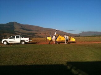
![<strong>Dernières vérifications avant le décollage de l'autogyre (EXIGE SA). Deux magnétomètres sont installés sur les flancs afin de réaliser une cartographie aéromagnétique en Afrique du Sud. (photo M. Munschy)</strong> Dernières vérifications avant le décollage de l'autogyre (EXIGE SA). Deux magnétomètres sont installés sur les flancs afin de réaliser une cartographie aéromagnétique en Afrique du Sud. (photo M. Munschy)](/websites/_processed_/0/9/csm_Autogyre_compres_4f83067769.jpg)
Dernières vérifications avant le décollage de l'autogyre (EXIGE SA). Deux magnétomètres sont installés sur les flancs afin de réaliser une cartographie aéromagnétique en Afrique du Sud. (photo M. Munschy)
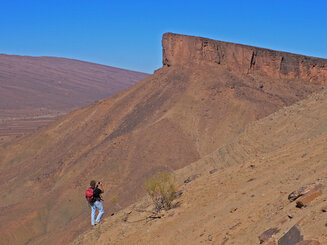
![<strong>Les affleurements de l'Anti-Atlas au Maroc recèlent un enregistrement sédimentaire complet de la glaciation fini-ordovicienne qui affecta le Gondwana il y 443 millions d'années (photo JF Ghienne)</strong> Les affleurements de l'Anti-Atlas au Maroc recèlent un enregistrement sédimentaire complet de la glaciation fini-ordovicienne qui affecta le Gondwana il y 443 millions d'années (photo JF Ghienne)](/websites/_processed_/1/3/csm_BouIngarf_530517e1e4.jpg)
Les affleurements de l'Anti-Atlas au Maroc recèlent un enregistrement sédimentaire complet de la glaciation fini-ordovicienne qui affecta le Gondwana il y 443 millions d'années (photo JF Ghienne)
![<strong>Clinoptilolite néoformée dans les carbonates miocènes de la plateforme des Bahamas (ODP 166), par la dissolution de silice biogène (photo A.M. Karpoff)</strong> Clinoptilolite néoformée dans les carbonates miocènes de la plateforme des Bahamas (ODP 166), par la dissolution de silice biogène (photo A.M. Karpoff)](/websites/_processed_/9/9/csm_Clinoptilolite_compres_cfcd0411d6.jpg)
Clinoptilolite néoformée dans les carbonates miocènes de la plateforme des Bahamas (ODP 166), par la dissolution de silice biogène (photo A.M. Karpoff)
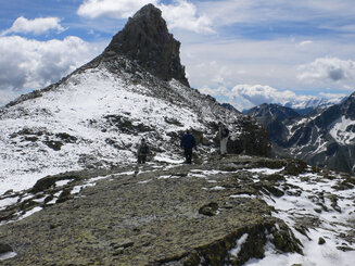
![<strong>Géologues marchant sur la faille de détachement de l'Err (Grisons, Suisse). Cette faille a exhumé les péridotites du manteau lors de l'ouverture de la Tethys (photo JF Ghienne)</strong> Géologues marchant sur la faille de détachement de l'Err (Grisons, Suisse). Cette faille a exhumé les péridotites du manteau lors de l'ouverture de la Tethys (photo JF Ghienne)](/websites/_processed_/b/4/csm_Err_4abab46fb4.jpg)
Géologues marchant sur la faille de détachement de l'Err (Grisons, Suisse). Cette faille a exhumé les péridotites du manteau lors de l'ouverture de la Tethys (photo JF Ghienne)
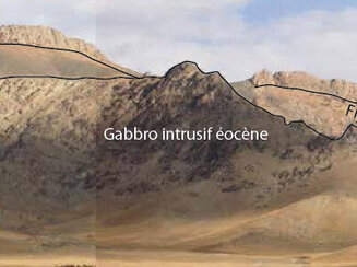
![<strong>Gabbro calco-alcalin éocène intrusif dans un flysch volcano-clastique éocène inférieur sur des andésites paléocènes de bassin arrière-arc, le tout recouvert par du calcaire transgressif miocène (Kermanshah, Zagros charrié au SW de l’Iran) (Ph</strong> Gabbro calco-alcalin éocène intrusif dans un flysch volcano-clastique éocène inférieur sur des andésites paléocènes de bassin arrière-arc, le tout recouvert par du calcaire transgressif miocène (Kermanshah, Zagros charrié au SW de l’Iran) (Photo H. Whitechurch)](/websites/_processed_/e/8/csm_Gabbros_9ebd3291fb.jpg)
Gabbro calco-alcalin éocène intrusif dans un flysch volcano-clastique éocène inférieur sur des andésites paléocènes de bassin arrière-arc, le tout recouvert par du calcaire transgressif miocène (Kermanshah, Zagros charrié au SW de l’Iran) (Ph
![<strong>Métasédiments plissés (type kink-bands) datant du Dévonien, Altaï chinois, Province du Xinjiang. (photo A. Guy)</strong> Métasédiments plissés (type kink-bands) datant du Dévonien, Altaï chinois, Province du Xinjiang. (photo A. Guy)](/websites/_processed_/e/8/csm_Metasedim_compres_8b195644ac.jpg)
Métasédiments plissés (type kink-bands) datant du Dévonien, Altaï chinois, Province du Xinjiang. (photo A. Guy)
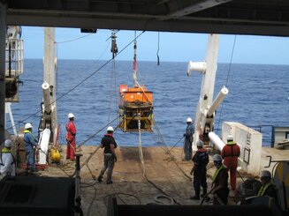
![<strong>Mise à l'eau du sonar latéral TOBI depuis la plage arrière du N/O Marion Dufresne durant la campagne SmoothSeafloor afin de cartographier le plancher océanique avec une résolution décamétrique (dorsale sud ouest indienne). (photo D. Sauter)</strong> Mise à l'eau du sonar latéral TOBI depuis la plage arrière du N/O Marion Dufresne durant la campagne SmoothSeafloor afin de cartographier le plancher océanique avec une résolution décamétrique (dorsale sud ouest indienne). (photo D. Sauter)](/websites/_processed_/4/a/csm_TOBI_compres_28cf845d54.jpg)
Mise à l'eau du sonar latéral TOBI depuis la plage arrière du N/O Marion Dufresne durant la campagne SmoothSeafloor afin de cartographier le plancher océanique avec une résolution décamétrique (dorsale sud ouest indienne). (photo D. Sauter)
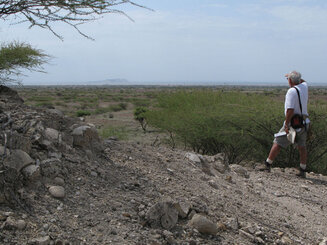
![<strong>Dépôts lacustres (stromatolites) pliocènes de la Formation de Nachukui perchés au-dessus du niveau actuel du lac Turkana visible en arrière-plan avec l'île volcanique du Nord (Rift Est-africain, Kenya) (photo M. Schuster)</strong> Dépôts lacustres (stromatolites) pliocènes de la Formation de Nachukui perchés au-dessus du niveau actuel du lac Turkana visible en arrière-plan avec l'île volcanique du Nord (Rift Est-africain, Kenya) (photo M. Schuster)](/websites/_processed_/c/a/csm_Turkana_f10c18e9be.jpg)
Dépôts lacustres (stromatolites) pliocènes de la Formation de Nachukui perchés au-dessus du niveau actuel du lac Turkana visible en arrière-plan avec l'île volcanique du Nord (Rift Est-africain, Kenya) (photo M. Schuster)
![<strong>Echantillonnage pour datation par thermoluminescence d'un plancher intra-karstique (Chaîne Anamitique, Vietnam) (photo P. Duringer)</strong> Echantillonnage pour datation par thermoluminescence d'un plancher intra-karstique (Chaîne Anamitique, Vietnam) (photo P. Duringer)](/websites/_processed_/1/b/csm_vietnam_bb3d487811.jpg)
Echantillonnage pour datation par thermoluminescence d'un plancher intra-karstique (Chaîne Anamitique, Vietnam) (photo P. Duringer)